Photo Credit
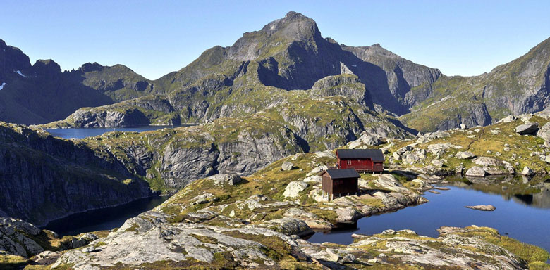
Munkebu Hut on the island of Moskenes
Credit: David Wilkinson
Munkebu Hut on the island of Moskenes
Credit: David Wilkinson
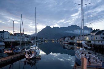
The Lofoten Islands are a grand stage for hiking. Many of the trails have far-reaching views of the mountain spires and sea, and they range from easy beach walks to steep, challenging treks into the Lofoten backcountry. The island of Moskenesøya makes a terrific base, although virtually everywhere on the Islands is close to a trail. Digital maps are available by clicking the "map" link for each hike; trails are represented by the red dotted lines. Norwegian Trekking Association (DNT) maps can be purchased through the DNT or locally in Norway. Those interested in hiring a guide should inquire with Reine Adventure located near the Reine Rorbuer. The weather is variable so bring layers and keep a close eye on the conditions.
Starting point: Reine (see map)
Duration: 2-3 hours round trip
Difficulty: Short but challenging
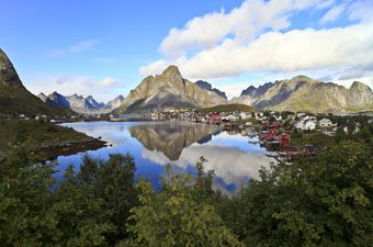
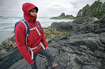
This viewpoint is one the biggest on all the Islands—a steep scramble to an epic panorama of Reinefjorden and the improbable Lofoten Wall. Reinebringen is only 448 meters high but the hike is essentially straight up, sometimes slippery, and challenging overall (leave plenty of time to enjoy the views at the top). From the parking area just outside of town toward the village of Å, the E10 passes through a tunnel (Ramsvikstunnelen). The hiking trail can be found on the other side of the tunnel where the paved footpath connects back to the road. Camping is possible near the top but the area is very exposed and water is not available.
Editor’s note (June 4, 2019): The trail to Reinebringen currently is undergoing construction, and intermittent closures will be in effect until work is completed. According to the most recent update, the trail is closed for all use until July 14, 2019. For the most up-to-date information, see the Reinebringen Facebook page before your visit.

Starting point: Ferry from Reine to Kjerkfjorden (see map)
Duration: 4 hours round trip
Difficulty: Moderate
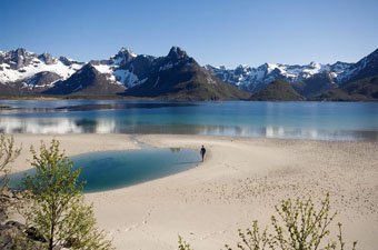
Start this hike by taking the 15-minute Fjordkyss morning ferry from Reine to the hamlet of Kjerkfjorden (departs from Reine at either 8:00am or 10:00am in the high season). Upon disembarking, turn right from the pier and follow the signs to the trail. Horseid Beach, a magnificent patch of white sand surrounded by towering granite, is approximately two hours of easy walking in each direction. Pack a lunch and make sure to be back at Kjerkfjorden for the return ferry at 3:15pm (45 minutes back to Reine via Vindstand).
Starting point: Ferry from Reine to Vindstad (see map)
Duration: 2-3 hours round trip
Difficulty: Easy
The walk to Bunes Beach is similar to Horseid beach only shorter. Take the same morning Fjordkyss ferry from Reine to the village of Vindstad (25 minutes). At Vindstad follow the path northwest alongside the fjord, over the ridge, and down to the beach. The walking is relatively easy and good for families (approximately 1–1½ hours in each direction, 2–3 hours total). The return ferry leaves Vindstad at 3:25pm (35 minutes back to Reine).
Starting point: Sørvågen (see map)
Duration: 5-6 hours round trip
Difficulty: Moderate to challenging
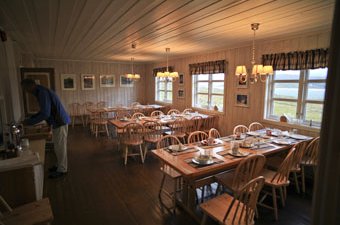
This intermediate-grade hike starts from Sørvågen, 1.5km east of the village of Å and the end of the E10, and rises through the Lofoten backcountry past four lakes en route to the stunning Munkebu hut (pictured above). The trip takes approximately 2½–3 hours each way with a 450 meter vertical rise (some sections require scrambling but metal supports are provided). Munkebu is also used as an overnight basecamp for hiking to the summit of Hermannsdalstinden (see below). The path begins from Lake Sørvågvatet and crosses over a series of ridges toward the hut. Munkebu is locked and cannot be opened with the normal DNT key; the Munkebu key can be obtained at Sørvågen Commerce (tel. 76 09 12 15) with a DNT membership card.
Starting point: Sørvågen (see map)
Duration: 1 day or more (you can stay at the hut)
Difficulty: Challenging
At an altitude of 1,029 meters, Hermannsdalstinden is the highest mountain in western Lofoten and offers the single most breathtaking view of the Islands (second place is Reinebringen). The hike is difficult with steep, exposed sections, loose rock, and potentially high winds. From Munkebu hut to the summit takes 6–8 hours round trip—fast and experienced trekkers can do the full hike from Sørvågen in a very long day (11–14 hours total). The most logical plan, however, is to stay at the hut or camp and enjoy the hike to the summit during the calmer morning weather.
Starting point: Island of Værøy (see map)
Duration: 4-6 hours round trip
Difficulty: Moderate
If you want to get way off the beaten path on the Lofoten Islands, try the Island of Værøy. This remote and underappreciated piece on the Lofoten archipelago has remained relatively untouched because getting there requires a ferry from Bødo or Moskenes. A terrific hiking route curves along its northern coast and crosses over to the deserted fishing village of Mostad (10km round trip). The trailhead starts 300m west of the old airstrip. Værøy is known for birdwatching and dramatic Mount Mostadfjell is home to more to more than one million nesting sea birds.

Starting point: Henningsvær (see map)
Duration: 2 hours round trip
Difficulty: Easy to moderate
This short and steady hike up Glomtinden (419m) ends with nice views, including the mountain of Vågakallen (943m) set against the ocean to the south, and the town of Svolvaer to the east. The round trip takes approximately 2 hours with an elevation gain of 300m. From Henningsvær, take the main road north and turn right at the E10. The trail begins at the first left hand turnoff after the road hits the lake (Rørvikvatnet).

Starting point: Stamsund (see map)
Duration: 2-4 hours round trip
Difficulty: Moderate
This is a gentle, longer walk (12km round trip) to one of Vestvågøy's highest peaks at 738m. The mountains of Vestvågøy aren’t as dramatic as those on Moskenesøya, but the hike to Justadtinden offers a nice range of Lofoten scenery and is one of the easiest, big views on the Islands. Access to the trail is approximately 4km east of Leknes on the 815 toward Stamsund.
Starting point: Village of Å (see map)
Duration: 6-8 hours round trip
Difficulty: Moderate to challenging
The scenic village of Å is the end of the road on the Lofoten Islands—this is the terminus of Highway E10. Starting from the west side of the village, the hike crosses the outer edge of Moskenesøya with western views along the way. Allow 6-8 hours for the round trip, which has steep sections and can be soggy. Make sure to keep an eye out for the trail as you hike, which is partially marked.
Starting point: Nusfjord (see map)
Duration: 3-4 hours round trip
Difficulty: Moderate
Start from the bay in Nusfjord (a UNESCO World Heritage Site) on Moskenesøya, and follow the coastal path south to Nesland. The round trip takes approximately 3–4 hours with moderate scrambling. Inquire in Nusfjord before you set out for a map and more details.
Editor’s Note: We took great pride in creating this list of Lofoten hikes, but we also wanted to give praise to photographer Cody Duncan and his site www.68north.com. Cody spends a lot of time on the Islands each year and has done a great job documenting Lofoten hikes with maps and photos. You can check out his write-ups on hikes like Reinebringen and Kvalvika Beach, for example. Cody also is a terrific landscape photographer and you can read our interview with him here.

")