There is very little about California that hasn’t already been said. Yosemite filled Albert Bierstadt’s canvases and Ansel Adam’s lenses. The Pacific Coast off Highway 1 inspired John Steinbeck and Jack Kerouac’s notebooks. The twisted landscapes of Joshua Tree even inspired a seminal U2 album. California is a land of many faces, from the soaring peaks of the Sierras, to giant sequoias, the arid Mojave, and capped with the granite monoliths of the Yosemite Valley. Creating a “best of” compilation of California hikes is a tall task because of the sheer number of landscapes, trails and parks.
The hikes that we’ve selected below represent California in its finest forms: the coastlines, deserts, woodlands, and peaks that draw adventurers from all over the world. You’ll find hikes from all parts of the state and options from short day hikes to challenging multi-day backpacking trips. Enjoy!
Easy to Moderate Day Hikes
Point Lobos State Reserve (South of Monterey)
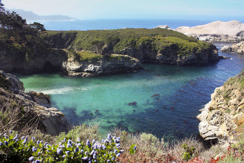 In many ways, Point Lobos State Reserve is all the beauty of the California Coast in a nutshell. Despite being close to the touristy towns of Monterey and Carmel, Point Lobos is one of the most impressive State Parks we’ve ever visited. The trails are well-kept, easy to follow, and hug the spectacular coastline with ample opportunities to soak up the scenery. If anywhere down the road on Highway 1 is markedly more beautiful, we didn’t see it. To explore Point Lobos, exit Highway 1 approximately 7 miles south of Monterey. The road through the Park is a loop from the main entrance south to Pelican Point (it’s actually a one-way that requires you to backtrack to get out). Parking can be tough but find a space and head toward the numerous trails that skirt the coast—the South Shore Trail, Cyrpress Grove Trail, and North Shore all are spectacular for scenery and wildlife viewing. During the right time of year, migrating gray whales can be seen in the distance.
Type: Day hike
Difficulty: Easy
Length: Variable
More info: Point Lobos Foundation
Ryan Mountain (Joshua Tree National Park)
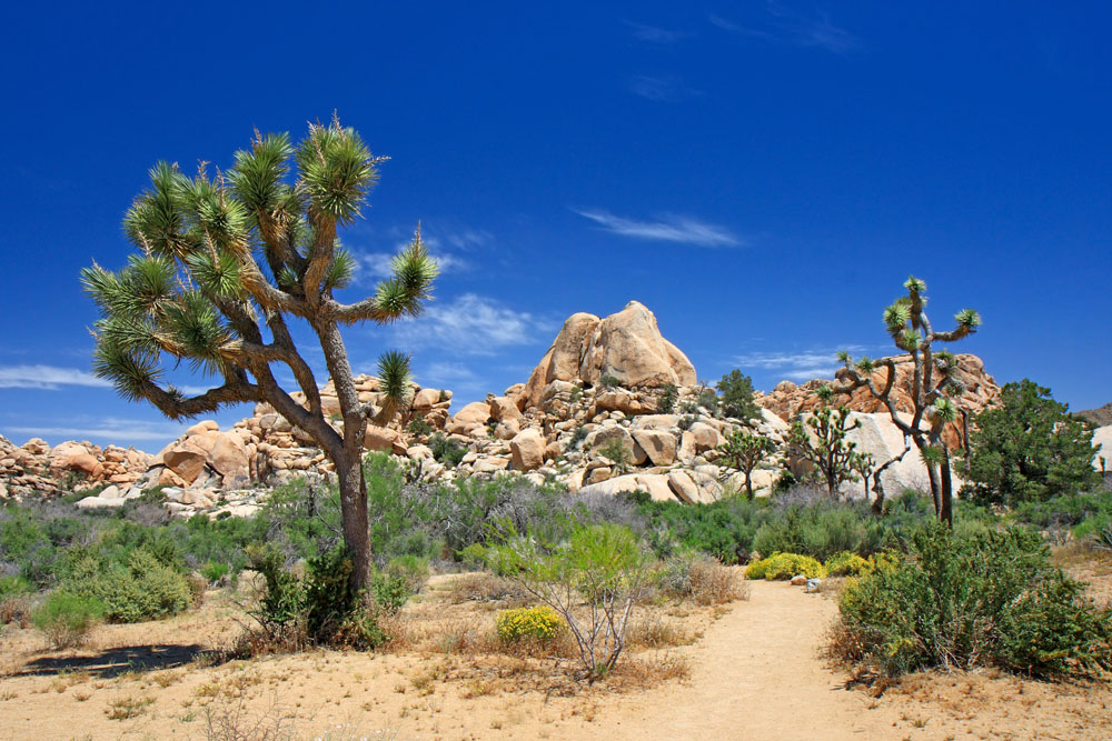 Simply put, Joshua Tree’s landscapes are otherworldly. The twisted branches of the park’s namesake trees rise up from the golden, arid, rock and sand desert. At its heart, Ryan Mountain rises 5,475 feet above the desert floor, offering an overlook of sagebrush, contorted wooden limbs, and towering rock formations. The trail starts climbing right from the start at Park Boulevard, and stone steps cut into the rock path to the summit in only 1.5 miles. After a junction, a curve takes hikers around the west face with views of stone towers and vast boulder fields. As the loop dissipates for the final walk towards the top, two false summits will test your patience before a final 400-foot climb to the summit plaque. Cacti, desert flowers, and wiry shrubs line the slopes and this view is among the best in the park.
Type: Day hike
Difficulty: Easy to moderate
Length: 3 miles roundtrip
More info: California Through My Lens
Moro Rock (Sequoia National Park)
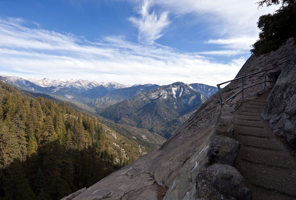 The trail to the top of Moro Rock—a granite monolith in Sequoia National Park—is less than a mile in distance but very steep and supremely exposed. In the short march to the top, the trail climbs over 350 stairs while crossing ledges that can make any hiker nervous (in some places there is enough space for only one person at a time). At the high point of Moro Rock, an overlook offers tremendous views of the snow-capped Sierra Nevada mountains with Mt. Whitney, the highest peak in the Lower 48, just out of view (even without this peak the view is mesmerizing). The route can be hazardous in stormy weather but is well worth it on clear days.
Type: Day hike
Difficulty: Easy to moderate
Length: .6 miles roundtrip
More info: NPS
The Mist Trail (Yosemite National Park)
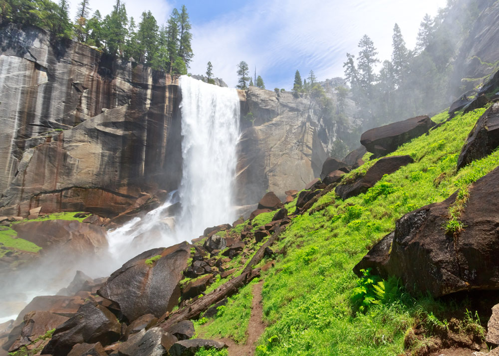 The Mist Trail in Yosemite offers close-up encounters with two of the Park’s most popular waterfalls: Vernal and Nevada. From Happy Isles, the trail runs parallel to a riverbank followed by an ascent to a footbridge overlooking Vernal Falls. As water crashes down off the cliff face, the trail passes up granite steps on the right side (at this point you are very close to the cascading water, making the rock and footpath quite slippery). The trail then skirts the Emerald Pool and continues up a second staircase to the gargantuan Nevada Falls. Hikers then converge with the John Muir Trail and rejoin the main path at the footbridge. Because of the mist-covered trails, visitors should watch their step, have adequate gear, and admire the falls from behind the barriers.
Type: Day hike
Difficulty: Easy to moderate
Length: 7 miles roundtrip
More info: NPS
Moderate to Challenging Day Hikes
Cataract Trail Loop (Marin County)

With miles of trails to choose from around the Bay Area, the Cataract Trail Loop in Marin County is among the best. Weaving through forests, cascading waterfalls, and along grassy hilltops, this trail in an oasis relatively close to the city. The loop starts out in dense redwood forests, walking parallel to Cataract Creek to a moss-covered waterfall naer wildflower fields. A short climb leads to the Laurel Dell picnic area (a nice spot for a rest), where the path joins the High Marsh Trail. Here, the trail crosses exposed grassy hills with spectacular views of Marin County. The High Marsh then intersects the Kent Trail, bringing hikers to Alpine Lake. The final section of the trail climbs 600 feet and rejoins the Cataract Trail, passing several more waterfalls before returning to the trailhead.
Type: Day hike
Difficulty: Moderate
Length: 7.7 miles roundtrip
More info: Every Trail
Cathedral Lakes (Yosemite National Park)
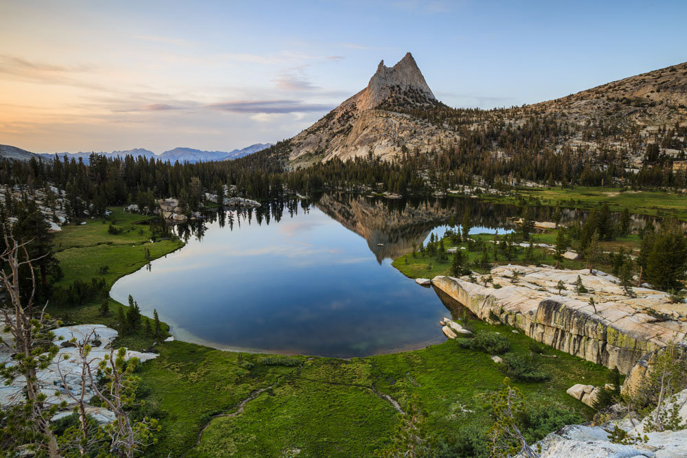 Upper and Lower Cathedral Lakes are set dramatically in a bowl in the heart of Yosemite's Tuolumne Meadows. With surrounding granite peaks reflecting in their waters, the lakes are part of one of the most popular and scenic hiking areas in Yosemite. The Cathedral Lakes trailhead is accessible from Tioga Road, which is open from May through early November. You begin by crossing a creek before climbing quickly to Upper Cathedral Lake, which is surrounded by 10,000-foot mountains: Echo and Tresidder Peaks to the south and Cathedral to the north. The trail then backtracks to the junction for Lower Cathedral Lake, which has a rocky sloping shore that’s perfect for resting and a wider, fuller view of the peaks (deer frequently walk along the lake’s edge to graze and drink). The trail then returns to the junction and follows the same path back to Tioga Road.
Type: Day hike
Difficulty: Moderate
Length: 8 miles roundtrip
More info: Yosemite Hikes
The Panorama Trail (Yosemite National Park)
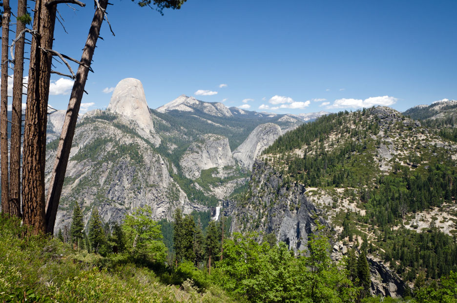 The Panorama Trail packs in a number of Yosemite’s highlights as it passes from Glacier Point down to the Valley Floor (the trail can be done uphill or downhill but most people prefer downhill). From the trailhead at Glacier Point, the Yosemite Valley sprawls out before you: Half Dome dominates the landscape with Liberty Cap rising across the valley and two waterfalls (Vernal and Nevada) cascading from the shelf. Approximately two miles in, the trail leads to a perch before Illiouette Falls, with water thundering down 370 feet off the cliff. The downhill then becomes steep, dropping over 1,000 feet in 3 miles through a pine forest and emerging on Panorama Cliff for views across the Valley toward North Dome and Royal Arches. Coming upon the Valley floor, hikers may join the John Muir Trail to Happy Isles, or for a more intriguing variation, cool off on the Mist Trail before proceeding to the trailhead.
Type: Day Hike
Difficulty: Moderate to challenging
Length: 8.9 miles one-way
More info: Yosemite Hikes
Mt. San Antonio (Mt. Baldy) Loop (San Gabriel Mountains)
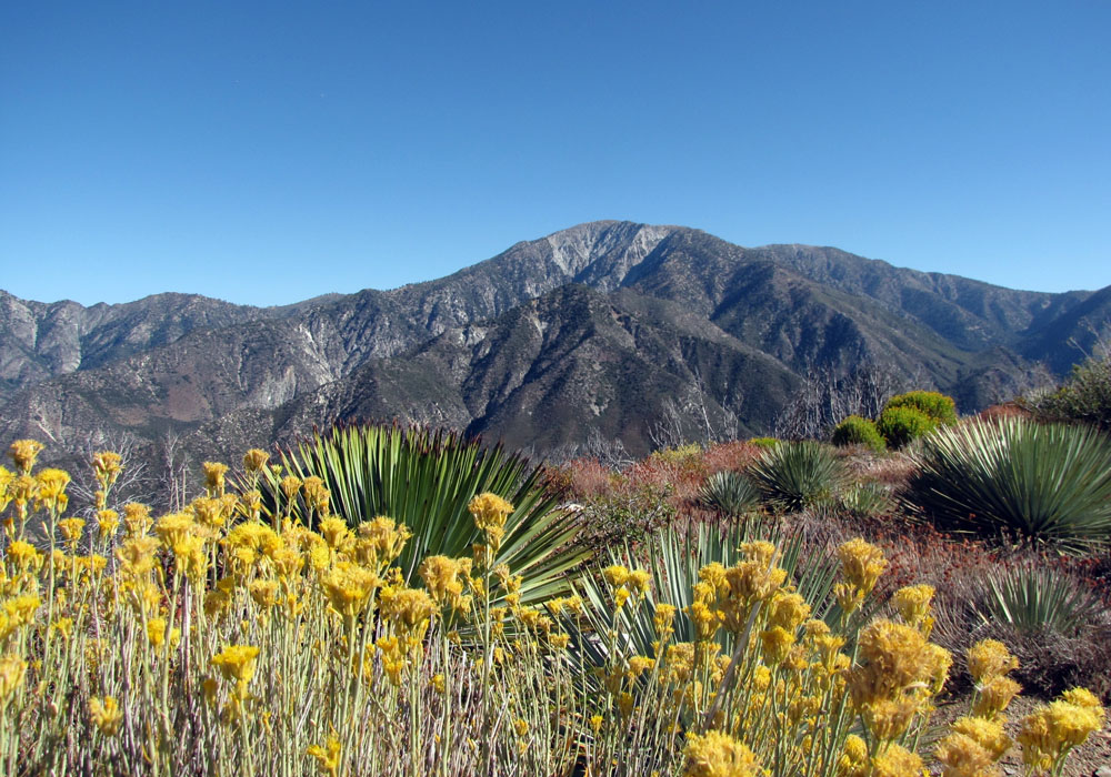 Mt. Baldy is the tallest peak in the San Gabriel Mountains and the trek up is a Southern California classic. Although lofty and exposed, the route isn’t overly strenuous and is well suited for most hikers (and their dogs). The trail begins at Manker Flats and loops around hairpin turns under San Antonio Falls. Visitors soon arrive at the Baldy Ski Resort, which has a restaurant and a ski lift (when operating, hikers can cut 1,500 vertical feet off the hike by taking it to the top of Baldy Notch). Otherwise, a trail ascends the dry ski runs to the Devil’s Backbone trailhead. The lower saddle leads up a strenuous 700 feet to the summit of Mt. Baldy. The peak is open, rocky, and windy, and there are several improvised wind shelters to block the gusts. Snow will linger around the peak until early summer. After taking in the landscape, the route descends via the Baldy Bowl to a Sierra Club ski hut before merging with San Antonio Falls.
Type: Day hike
Difficulty: Moderate to challenging
Length: 10.4 miles roundtrip
More info: SoCal Hiker
Half Dome Cable Route (Yosemite National Park)
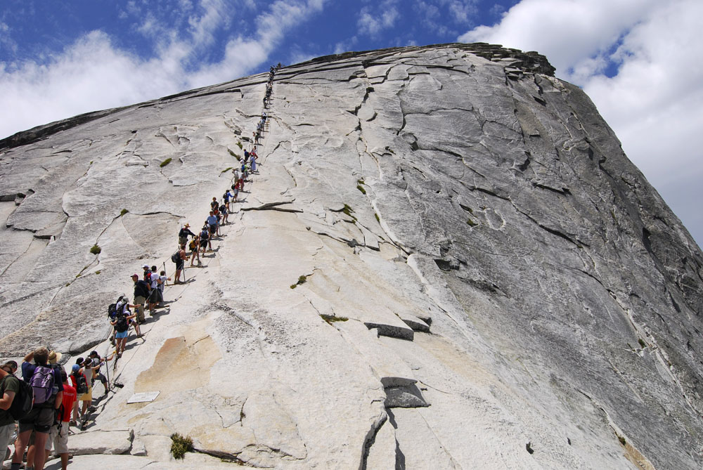 Culminating at the top of Yosemite’s most famous landmark, The Half Dome Cable Route is one of California’s most iconic and challenging hikes. This is a full-day excursion that is best undertaken with good conditions and preparation: hiking boots, trekking poles, rubber gloves for the steel cables, and plenty of water are necessities on this tough but rewarding trek.
The trail begins by following the Mist Trail (above) to the intersection with the John Muir Trail. A steep incline ascends to Little Yosemite Valley, a “base camp” at the Half Dome trailhead. After a traverse through a lush pine forest often populated by deer and black bear, a series of switchbacks climb to the base of Sub Dome. From there, hikers begin to tread on granite as the tree line falls away. A ranger checks permits and the 400-foot climb up the cables begins here. The path is steep, exposed, and treacherous when wet. The route can become crowded and bottlenecks are common, so try to let faster parties pass when resting.
Gradually the route rounds out as it approaches the summit, and the majestic vista from the top is superb. El Capitan dominates the skyline across the Valley with Cloud’s Rest and Mt. Dana nearby. Tenaya and Merced Canyons sprawl out below as the snow-capped peaks beyond Tuolumne Meadows glisten in the distance (one of the most popular photo opportunities is “The Visor,” a platform that juts out near the northwest corner of Half Dome). After enjoying the view, the best way to hike down the cables is in rappel fashion: face the rock and carefully move back down the mountain. After descending to Sub Dome, the trail retraces its route to Nevada Falls and Happy Isles.
Type: Day Hike
Difficulty: Challenging
Length: 15.7 miles roundtrip
More info: NPS
Backpacking Trips
Mt. Whitney (Sequoia National Park)
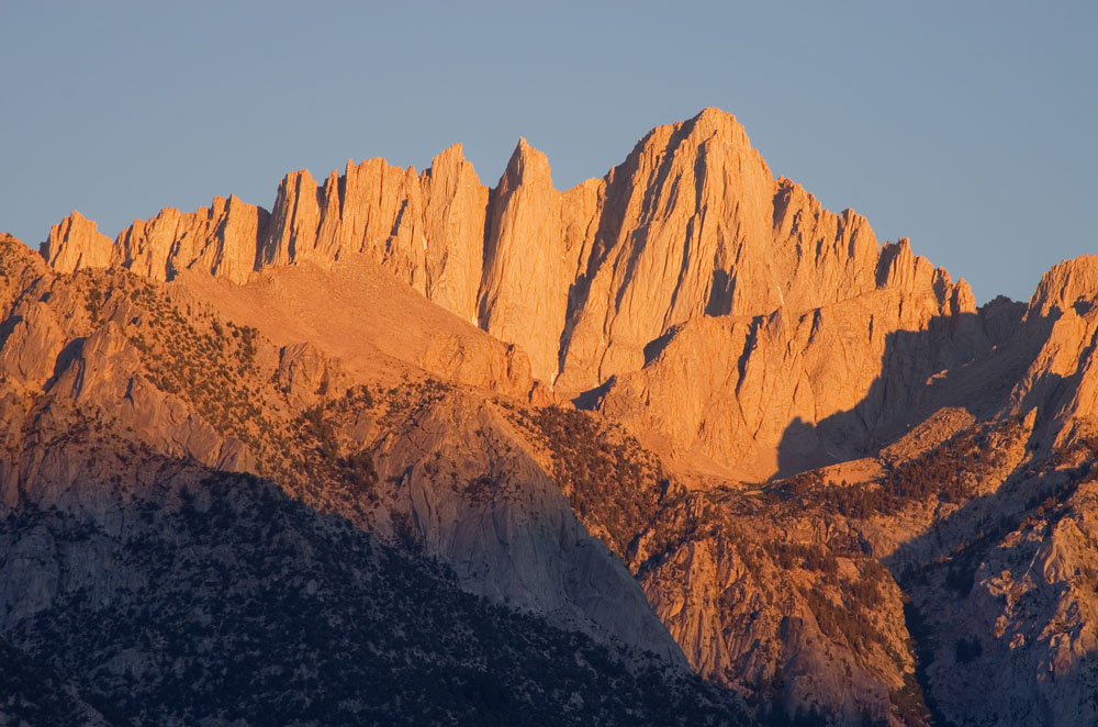 At 14,505 feet, Mt. Whitney is the tallest peak in the Lower 48 and the queen of the Sierra Nevada. While the total time of a summit trip can range anywhere from 14 to 20 hours, it’s best to ascend Mt. Whitney over two days to get an early start. Its southern placement makes the mountain mostly immune to glacial buildup, but snow can accumulate in the early season requiring the use of crampons and ice axes. At any time of year, it’s a very challenging hike.
Starting from Whitney Portal, the trail ascends through a sub-alpine forest to Lone Pine Lake (an excellent day hike in itself). A rocky moraine then brings climbers into the Whitney Zone, the official climber’s path where permits are required. Several switchbacks lead to Outpost Camp, where the grass falls away and the landscape becomes rockier and barren. Hikers then pass Consultation Lake, spectacularly placed in a granite bowl, and set tents at Trail Camp, which serves as the base for a summit attempt.
The try for the top starts in the early hours of the morning with a 1,700-foot ascent up the infamous “99 Switchbacks.” When the climb is at its steepest, a 50-foot section of cables keep climbers from slipping off the west edge. At over 13,000 feet, climbers loop around the back to begin the five-mile walk towards the summit ridge (make sure to take the high altitude into consideration). A steep couloir rises above Hitchcock and Guitar Lakes followed by a short scramble to the summit. At the top is a wind shelter with a guest book, a great place to rest for the return trip down.
Type: Backpacking trip
Difficulty: Challenging
Length: 22 miles roundtrip
More info: NPS
Lost Coast Trail (Northern California)
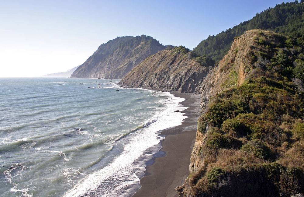 Novelist John Steinbeck described the California Coast as “a few sloping acres above a cliff that dropped to the brown reefs and to the hissing white waters of the ocean.” The Lost Coast Trail—a section of North California coastline deemed too rugged for the Pacific Coast Highway—spans over 24 miles under rust-colored cliffs, golden sand beaches, and the gothic-like sea towers. All things considered, it’s among America’s best coastal hikes.
This 24.8-mile route can be done in either direction, from the northern trailhead at Mattole or the southern trailhead at Black Sands Beach. Along the way, you can expect miles of grainy coastline, crashing waves, waving grass fields dotted with wildflowers, old homesteads, and even an abandoned lighthouse at Punta Gorda. Early mornings are spectacular as fog and dew roll off the cliff faces toward the rock formations and boulder-strewn beaches. Certain sections may become hazardous as the tide washes higher, and there are several hillsides to find shelter until the trail is passable again. Allow 2 to 3 days or more to cover the full distance.
Type: Backpacking trip
Difficulty: Challenging
Length: 24.8 miles one-way
More info: BLM
High Sierra Trail (Sequoia National Park)

The 49-mile High Sierra Trail is a spectacular east-to-west traverse through the Sierra Nevada high country—it’s more alpine-focused than the longer John Muir Trail below and all its entire duration is among high mountain scenery.
From the trailhead at Crescent Meadow (6,700 feet), there is an immediate 11-mile climb up the canyon from the Kaweah River up the Great Western Divide known as the Keaweah Gap (10,700 feet). As the trail enters the alpine zone at Moraine Lake, hikers head toward the Chagoopa Plateau and into the Kern Canyon (if you’re already sore, there is a natural hot spring here to relieve aching muscles). The High Sierra Trail technically ends at the junction with the John Muir Trail, but many hikers continue on another 13 miles to the summit of Mt. Whitney. The total distance from Crescent Meadow to the Whitney Portal is just over 72 miles.
Type: Backpacking trip
Difficulty: Very challenging
Length: 49 miles one-way (72 miles to Whitney Portal)
More info: NPS
John Muir Trail (Yosemite, Kings Canyon, and Sequoia National Parks)

The John Muir Trail, named for the time-honored hero of conservation, is California’s most legendary trek. In addition to summiting California’s highest peak, Mt. Whitney, the John Muir Trail traverses seven passes and rarely dips below 8,000 feet. Spanning 211 miles through Yosemite, Kings Canyon and Sequoia National Parks, the trail starts at Happy Isles in Yosemite and ends at Lone Pine Lake beneath Mt. Whitney. The full thru-hike can take up to three weeks at a steady pace.
The most popular way to hike the John Muir Trail is from north to south with resupply points at Tuolumne Meadows, Reds Meadow, Vermillion Valley, and Muir Trail Ranch. The trail begins at Happy Isles and connects the Mist, Panorama, and Cathedral Lakes Trails before ascending out of Yosemite via 11,050-foot high Donahue Pass. The John Muir Trail then enters Inyo National Forest and the Ansel Adams Wilderness with a resupply point at Reds Meadow (and the option to take a shuttle to Mammoth Lakes).
After traversing several high lakes and exposed ridges, the trail then crosses into Kings Canyon National Park. LeConte Canyon and the LeConte Ranger Station provides hikers with the last resupply stop before a section called The Golden Staircase rises to above 12,000 feet. After traversing Mather and Pinochet Pass, the trail passes by Dollar, Arrowhead, and Rae lakes, as well as the Kearsarge Pinnacles. The trail then rises over 13,200-foot Forester Pass, the highest on the trail. From here, hikers come to a junction with the Pacific Crest Trail junction and can follow the two-mile rocky path to summit Mt. Whitney. The last overnight is at Outpost Camp before a final descent to Lone Pine Lake, Whitney Portal, and the end of the epic John Muir Trail.
Type: Backpacking trip
Difficulty: Very challenging
Length: 211 miles one-way
More info: Pacific Crest Trail Association