Photo Credit
Switchback Travel
Switchback Travel
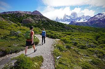
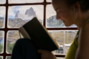
The Huemul (pronounced wey-mool) Circuit is a challenging, 40+ mile trek located in Parque Nacional Los Glaciares, just outside of the Patagonia trekking mecca of El Chaltén, Argentina. The trek starts in El Chaltén and ends on the banks of Lago Viedma, journeying through meadows and forests, across rivers and up windy passes, along rocky moraines and beside iceberg-laden bays. The highlight of the Huemul Circuit is the unparalleled view of the Southern Patagonian Ice Field, the second-largest non-polar ice mass in the world. No other trek in southern Patagonia offers such a view—even in the El Chaltén area, the ice cap is most often obscured by the towering summits of the Fitz Roy and Cerro Torre mountain massifs. Most trekkers complete the Huemul Circuit in four days, weather permitting. Below we provide day-to-day breakdown on what to expect, plus details on difficulty, gear, navigation, the Tyrolean traverse, permits, and more. To learn more about trekking in the area, see our article on the best hikes in El Chaltén, Argentina.
.gif)
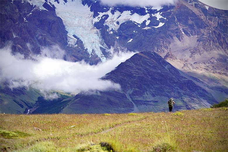
Length: 16 kilometers (10 miles)
Elevation: 2500’ gain, 2100’ loss
Difficulty: Moderate
Campsite amenities: Primitive toilet, emergency shelter, ~20 tent sites, water collected from the river
Depart from El Chaltén, leaving on the main trail from the ranger station on the southern end of town. After less than a quarter mile, turn right at the first junction, following the sign for Laguna Toro. The trail will take you high above town through open fields and enchanted beech-tree forests, with the occasional glimpse of the towering peaks of the Chaltén ranges to your right. After a few miles, you’ll find another junction set amongst a pasture with grazing cows—take a left here, again following signs for Laguna Toro. .jpg)
Continue through similar terrain as the dramatic massif of Cerro Huemul begins to dominate the skyline. Here the trail descends into the valley leading to Laguna Toro. If the weather has been warm, take note that you will need to navigate a few knee-high river crossings and an exceptionally wet footpath. The trail can be difficult to follow here in the valley—look for cairns and stay close to the riverbed until you reach Campamento Laguna Toro (Toro Camp) on your right, a series of tent sites nestled in the forest and sheltered from the raging wind. .jpg)
Length: 15 kilometers (9.3 miles)
Elevation: 3000’ gain, 2200’ loss
Difficulty: Difficult
Campsite amenities: Emergency shelter, no outhouse, ~10 tent sites, water collected from river
Leaving the Laguna Toro campsite, you’ll wind around the right side of the lake, following a trail and cairns up and over a few rocky mounds to reach the heralded Tyrolean traverse (see our section on that below). If the river is especially low, you may be able to ford it above the Tyrolean. If not, cross the raging river high on the steel cable and begin a long, gentle climb to Paso del Viento. When it seems most straightforward, you’ll leave the moraine and descend to the glacier, straying no more than 20-30 feet from the hillside. Surprisingly, travel is much easier and more efficient on the glacier, so stay on it until the hillside begins to rise steeply and the glacier provides easy access back to the moraine. The trail’s grade steepens here and two paths present themselves—take your pick, as each leads to Paso del Viento. .jpg)
Once over the pass, route-finding can again be tricky. With the ice field now in sight, your goal is to contour down and left toward the valley between the hillside and the moraines that line the ice cap. There is a route marked by cairns, but if you cannot find it, know you will reconnect with the trail in the small river valley below. Here, the trail follows cascading streams gradually downhill to a small lake and camping near the rustic Refugio Paso del Viento (translation: shelter from the windy pass, which is entirely accurate)..jpg)
Length: 18 kilometers (11.2 miles)
Elevation: 2100’ gain, 4400’ loss
Difficulty: Difficult
Campsite amenities: No outhouse, less than 10 tent sites, water collected from lake
From the campsite at Refugio Paso del Viento, continue on the trail as it contours along the hillside and offers incredible views up and down the ice field. The trail slowly climbs to Paso Huemul—soak in your last glimpse of the ice cap here before descending into drastically different landscape and weather on the other side. Descend steeply through forest (pleasant campsites are available in a grove beside a stream, roughly 1,000 feet below the pass), down an especially steep section containing a fixed rope, and all the way to the lowlands above Lago Viedma. Many find this dramatic descent to be one of the most difficult sections of the hike. On the plateau above the shores of the lake, look for a red-topped post along the trail for the path that leads down and right to the campsites at Bahia de los Tempanos on Lago Viedma (note the peninsula that juts out into the lake— you’ll want to be turning off from the trail before reaching it). If the circuit is busy, it is likely that the small Bahia de los Tempanos campsite will be crowded. You can find alternative—and just as stunning—camping on the Península Ventisquero at a campsite called Bahia de Hornos, or further along the trail in many places beside the lake..jpg)
Length: 18-26 kilometers (11-16 miles)
Elevation: 1400’ total gain & loss
Difficulty: Moderate
Leaving your camp on the shores of Lago Viedma, follow the trail as it weaves through the grassy pampa beside the lake. A few river crossings might require you to wade, and the trail can easily be lost at these crossings. There are also many cow trails in this area that can be deceiving—when in doubt, do not stray too far from the lakeshore, and aim to ascend the hillside straight ahead at the low point closest to the lake. Here, the trail will stay high, overlooking the lake, and descend near the mouth of Bahía Túnel (Tunnel Bay). At the base of the hill you’ll encounter a sign displaying that you can go left to reach the second Tyrolean traverse, or right to ford the river. We recommend using the Tyrolean—you already know how to do it at this point, and this one is much mellower than the first. Fording the river here can be especially difficult at the end of the day or in warm temperatures. And fun fact: this is Rio Túnel, the same river you crossed via the Tyrolean on the second day of the trek!.jpg)
Once at Bahía Túnel, you have technically finished the Huemul Circuit, but the crux of the journey may still be ahead: getting back to El Chaltén. A boat service operates out of this bay during the high season, with tours from around 10am to 4pm. If you arrive inside this window, it’s likely you’ll be able to hitchhike easily back to town or catch a ride on a tour bus. If, however, you arrive after 4pm and are unable to find a ride, you can continue to follow the trail above the boat launch towards El Chaltén. This trail is roughly 6 miles to town, or 3 miles to Estancia La Quinta, from which you can call a taxi. .jpg)
The Huemul Circuit is not for everyone – in fact, there’s a reason why rangers don’t mention the trek unless you specifically ask them about it. The mileage is not necessarily long—about 40 miles over the course of four days—but it is involved. Think knee-high river crossings, walking along moraines and across glaciers, ascending 3,000 feet to high passes in 60+ mph gusts of wind, navigating unmarked trails and constant route-finding, and of course, dangling over rivers on the steel cables of Tyrolean traverses. You’ll need to be fairly resourceful and experienced to manage a trek of this kind. If you don’t feel up for the challenge, we recommend any number of the more casual day hikes or overnight trips in the area. That said, if you’re looking for an adventure, the Huemul Circuit is bound to provide. Furthermore, it is possible to hire a guide for the trek from one of the many guide companies in El Chaltén..jpg)
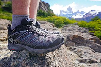
A four-day stint on the Huemul Circuit is a great way to put your backpacking gear to the test. In terms of hiking equipment, we recommend a mid-height hiking boot with a high-traction sole for ice and wet rocks, but one still comfortable enough to log mile after mile on flat trail. Additionally, waterproof footwear will be a huge asset on the wet, marshy terrain of Days 1 and 4. Be sure to bring a durable overnight pack that can carry around 60 liters. Lightweight, collapsible trekking poles are invaluable. .jpg)
Weather can change drastically in mere minutes in Patagonia, so an assortment of layers is essential. A rain shell or hardshell jacket can double as your wind protection, and be sure that your jacket has a high-quality hood that will stay on even in high winds. Furthermore, we recommend a breathable synthetic layer for hiking in inclement weather—with winds as strong as they are, the warmth and wind-proofing of an insulating layer is helpful. And lastly, the sun is more intense in Patagonia than you might be used to, so cover up with long sleeves, a hat, sunglasses, and sunscreen.
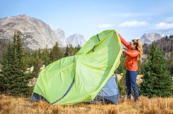
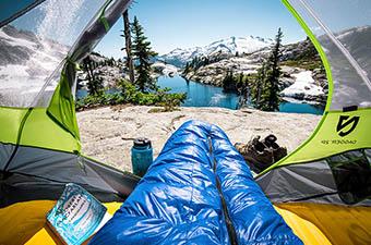
For camp, we can’t overstate our recommendation for a high-quality backpacking tent. You don’t need a four-season expedition tent to stay safe in the wind, but a sturdy, free-standing shelter with multiple attachment points to the ground is essential. You’ll want to bring a water filter or purification tabs, and a lightweight, wind-resistant backcountry stove. You can purchase both isobutene/propane canisters and white gas at many stores in El Chaltén. Additionally, because the campsites do not contain many boulders or logs to sit on, we were happy to have a lightweight insulated sleeping pad to lounge on, much like the Therm-a-Rest Z Lite..jpg)
In addition to the gear mentioned above, Parque Nacional Los Glaciares requires each group to carry a few specific items, including safety equipment for the Tyrolean traverse. To obtain your permit, you must present the following:
If you travel to Patagonia without some of the essential gear, many gear supply shops in El Chaltén rent a large range of camping and climbing equipment. Furthermore, all of the gear needed for the Tyrolean traverse is available for rent in town. Costs are reasonable and quoted at a daily rate.
Route-finding is one of the main cruxes of the Huemul Circuit. Many trekkers will travel with a GPS, but a great alternative is the smartphone app maps.me (be sure to pre-load the Argentina map). This app functions with data service turned off and Wi-Fi on, and will show you where you are with respect to the trail at any point on the circuit. We also recommend purchasing a laminated paper map of the area (required for the permit), available from many shops in El Chaltén, including the bookstore located on the main street in the southern part of town..jpg)
Because the trail is difficult to follow—or virtually nonexistent in many places—you’ll often need to pay attention to features to get from point A to point B. For example, you may lose the trail descending from Paso del Viento, but if you know that you need to aim for the small river valley at the base of the hill, you can just descend via the path of least resistance and regain the trail there. Knowledge of how to read a map, or the use of maps.me, will greatly help in these situations as well.
There is one mandatory Tyrolean traverse on the Huemul Circuit (Day 2), and one optional but highly recommended second traverse (the end of Day 4). Each hiker is required to show the requisite gear for the traverse (outlined in the Gear and Equipment section above) in order to obtain a permit. The park rangers of El Parque Nacional Los Glaciares provide very little instruction on how to set up and complete the traverse, so make sure you study up before setting out. Individual set-ups may vary, but a few components are essential:
*Note: always put the steel carabiner (not aluminum) on the steel wire..jpg)
Hikers frequent the Huemul Circuit most commonly between October and April. The heart of summer in Patagonia is January and February, but even during these months temperatures rarely rise above 70 degrees Fahrenheit. Surprisingly, summer also is the windy season in Patagonia. If you have yet to experience Patagonian winds, prepare yourself: these are the kind of knock-you-over-gusts that you won’t experience anywhere else in the world. .jpg)
All that said, we highly recommend checking the weather and chatting with the rangers at the park office before solidifying your dates. If necessary, Days 1 and 4 can be completed in inclement weather as they stay on relatively low and protected terrain. Days 2 and 3, however, both include high passes and significant exposure along the ice cap. They should not be undertaken in strong winds, under heavy precipitation, or with bad visibility. .jpg)
In general, water is plentiful along the Huemul Circuit. The park rangers will tell you that all of the water is potable because it flows straight from the glaciers. However, given the increasing popularity of this trek and the proximity of cows to your water sources on the first and last days, we highly recommend bringing along a water filter or purification tablets. If you do decide to drink the water without filtration, choose quick-moving water over the more stagnant water of lakes. The stream leading into the lake beside Refugio Paso del Viento, for example, is a much better source for drinking water than the lake itself. .jpg)
You must obtain a permit from the park office just south of El Chaltén before setting out on the Huemul Circuit. You can do this in the days leading up to your trek, or the morning of (the ranger station opens at 9am). In order to qualify for the permit, you must provide some personal information (including your passport number), bring in the required gear (see "Gear and Equipment" above), and watch a short presentation on the trek. We highly recommend taking pictures of some of these slides as they will help a great deal with navigation throughout the circuit..jpg)
Remember that when you arrive back in town, you must notify the park rangers that you have returned. You can either leave your registration form in a box outside of the station, or email the rangers with the email address provided on the form.
All information provided here is based on our experiences and research to the best of our ability, but the Huemul Circuit is a challenging trek that is done at your own risk. Distances, elevations, and difficulty are estimates only,. Make sure to take navigation seriously and check current regulations and weather conditions before leaving El Chaltén.